
|
|
Pixagri®
Pixagri® is a comprehensive service, available worldwide, that gives farming professionals more control over practices and inputs to achieve maximum profitability.
Pixagri helps you detect sub-field and inter-field variations at an early stage, thereby providing more precise information on which to base decisions. By giving you the “big picture”, it also lets you spot problems and thus spend less time walking fields. And at field level, Pixagri shows you where to focus your attention.
Pixagri gives you a more precise picture of your fields, making sure you take the right decision, at the right time and in the right place.
Pixagri is using a software application called Overland™ , which implements a unique image processing methodology that doesn’t depend on local and weather conditions. Because we understand that you need reliable information, at the right time and in the right place, our crop science domain experts work with you and systematically check maps before they are delivered.
Our maps are delivered in image formats (GeoTIFF, etc.) compatible with most geographic information software, thus allowing you to conduct sub-field and inter-field analysis from your office or in the field. Map files are interoperable and supported by a range of mobile and on-tractor systems.
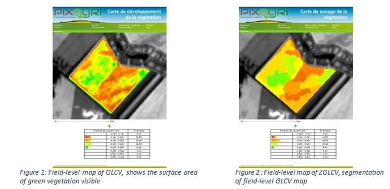
We also deliver fully annotated and printable maps in PDF format, giving you a strategic picture of crop condition at field level. And sub-field detail allows you to adapt seed density and application of inputs (water, fertilizer, etc.) to each crop.
Analysis of these maps generates direct quality benefits by helping you to optimize investment and effort through:
Pixagri® is a comprehensive service, available worldwide, that gives farming professionals more control over practices and inputs to achieve maximum profitability.
Pixagri helps you detect sub-field and inter-field variations at an early stage, thereby providing more precise information on which to base decisions. By giving you the “big picture”, it also lets you spot problems and thus spend less time walking fields. And at field level, Pixagri shows you where to focus your attention.
Pixagri gives you a more precise picture of your fields, making sure you take the right decision, at the right time and in the right place.
Pixagri is using a software application called Overland™ , which implements a unique image processing methodology that doesn’t depend on local and weather conditions. Because we understand that you need reliable information, at the right time and in the right place, our crop science domain experts work with you and systematically check maps before they are delivered.
Our maps are delivered in image formats (GeoTIFF, etc.) compatible with most geographic information software, thus allowing you to conduct sub-field and inter-field analysis from your office or in the field. Map files are interoperable and supported by a range of mobile and on-tractor systems.
We also deliver fully annotated and printable maps in PDF format, giving you a strategic picture of crop condition at field level. And sub-field detail allows you to adapt seed density and application of inputs (water, fertilizer, etc.) to each crop.
Analysis of these maps generates direct quality benefits by helping you to optimize investment and effort through:
- Farm diagnosis: inter-field and sub-field variations, identification of sources of variability, analysis to determine whether practices fit objectives.
- Support in optimizing practices to meet your short- and medium-term objectives.
- Monitoring implementation of new practices and their effectiveness.
More information here.
|
TERRA SPATIUM, Geoinformation and Space Products & Services- Private Security Services Company S.A.
90 Ioannou Metaxa Str., 19441, Karellas Koropi, Greece P.O. BOX 049 | 19002 Paiania Greece HELLENIC BUSINESS REGISTRY NUMBER: 9340801000 Tel.: +30 210 67 48 540 | Fax : +30 210 67 53 780 |
