|
Products/Airbus Defence & Space/Products & Services/Reference Layers/WorldDEM™
WorldDEM™ |
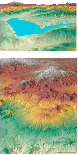
The WorldDEM™ is a global elevation dataset of unprecedented quality, accuracy, and coverage and will be available from 2014 for the Earth’s entire land surface - pole to pole. The accuracy of the WorldDEM™ will surpass that of any satellite-based global elevation model available today. The worldwide homogeneous acquisition guarantees a global DEM with no break lines at regional or national borders and no heterogeneities caused by differing measurement procedures or data collection campaigns staggered in time.
The unique and unrivaled combination of Coverage, Quality, Accuracy, and Availability of the WorldDEM™ sets a new standard in global elevation modelling.
KEY BENEFITS
The unique and unrivaled combination of Coverage, Quality, Accuracy, and Availability of the WorldDEM™ sets a new standard in global elevation modelling.
KEY BENEFITS
- Coverage: A standardised DEM for any spot on Earth at the same quality
- Quality: Allows you to close gaps in areas where no adequate DEM exists to date and extend to areas missing so far (cf. SRTM) with high accuracy
- Accuracy: Improve the performance of today’s globally operating navigation systems and applications :
- Relative vertical accuracy < 2m
- Absolute horizontal accuracy of < 10m
- Pixel size 12m
- Availability: Offers you easy and instant access to DSM basic due to an automatic order process and the global dataset being available, ensuring immediate delivery.
- Consistency: Highly consistent dataset thanks to data collection within 2.5 years only
- Percision: High geometric precision of the sensors make ground control information redundant
Standardised DEMs for any Point on Earth
Different Products for all your Application Needs
Airbus Defence & Space’s WorldDEM™ - which will be available from 2014 for the Earth’s entire land surface - provides a global dataset of unprecedented quality, accuracy and coverage. To help users take advantage of the highly precise elevation information, initially three core products will be available.
DSM Basic
 Elevation10
DSM basic
Elevation10
DSM basic
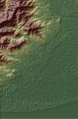
Sample figure: Elevation10 DSM basic The basic Digital Surface Model (DSM) includes the heights of all natural and man-made objects.
In the DSM basic all voids and artifacts are removed.
The DSM basic is an ideal elevation foundation that can be used to support a wide range of geospatial applications and services, including high quality image orthorectification.
DSM Hydro
 Elevation10 DSM hydro
Building on the DSM basic, the DSM hydro is a hydro-enforced digital surface model with water body features derived from the radar image.
Water surfaces of lakes and reservoirs are set to a single elevation, rivers and canals are flattened with monotonic flow, oceans are set to zero and coastal infrastructure features are removed.
DSM hydro provides a powerful solution for a broad range of applications, including water body identification and flood modelling.
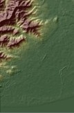
DTM
 Elevation10 DTM
The DTM represents the bare earth elevation with all vegetation and man-made objects removed.
This product provides detailed terrain information for even the most remote and difficult areas and reveals small-scale terrain structures that are covered by vegetation.
|
TERRA SPATIUM, Geoinformation and Space Products & Services- Private Security Services Company S.A.
90 Ioannou Metaxa Str., 19441, Karellas Koropi, Greece P.O. BOX 049 | 19002 Paiania Greece HELLENIC BUSINESS REGISTRY NUMBER: 9340801000 Tel.: +30 210 67 48 540 | Fax : +30 210 67 53 780 |
