• Home
  • CORPORATE
    • Profile
    • Partners
    • Memberships >
      • si-Cluster
      • EUGENIUS
      • ΕΒΙΔΙΤΕ
      • Ε.ΕΛ.Ε.Α.Α.
      • EARSC
    • Certifications
    • Financial Reports
    • Contact
    • Internal Portal
  • Products
    • Airbus Defence & Space >
      • Products & Services >
        • Satellite Imagery >
          • Optical >
            • One Tasking
          • Radar
        • Reference Layers >
          • SPOTMaps
          • GEO Elevation
          • WorldDEM™
          • Geological Mapping Studies
          • TerraSAR-X-based Ground Control Points
        • Software >
          • Pixel Factory
          • SAFEcommand
        • Easy Access to Data >
          • One Atlas
          • Cloud Services
      • Markets >
        • Defence Intelligence
        • Oil, Gas, Mines & Energy
        • Maritime Surveillance
    • e-GEOS >
      • VHR Optical
      • VHR Radar
    • INPHO / TRIMBLE
    • RIEGL >
      • Airborne Laser Scanning
    • SCHIEBEL
    • Θ|SAR Search & Rescue Platform
  • Projects
    • EUROPEAN >
      • H2020 >
        • EUGENIUS
        • FabSpace 2.0
      • NEPTUNE >
        • ABECE
        • World BioCoast
      • FP7 >
        • D-BOX
        • LOBOS
        • SAGRES
        • CHARMe
      • FRACTALS >
        • miBeez
    • NATIONAL >
      • Acritas
      • BEACHTOUR
  • Services
    • Precision Agriculture
    • Precision Viticulture
    • Monitoring Services >
      • Go Monitor
      • Global Seeps
  • NEWS & EVENTS
Terra Spatium
Products/Airbus Defence & Space/Products & Services/Satellite Imagery

Satellite Imagery

Reference Layers   Monitoring Services   Software   Easy Access to Data
Picture
With any point on Earth covered at least once a day, Astrium Services provides unrivaled access to the most comprehensive range of commercial Earth observation data available today.

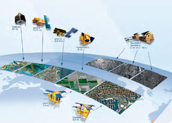
Airbus Defence & Space data products comprise imagery acquired by the Pléiades constellation, the SPOT constellation, TerraSAR-X, TanDEM-X and from partner satellites such as FORMOSAT-2 and DEIMOS-1.

As a satellite operator, with strong partnerships with other operators and their own airborne capabilities, Astrium provides access to the most complete range of Earth observation data on the market: an efficient answer to your needs for imagery whatever the scale, the location or the timeliness!

  • Unrivaled high-resolution operational data acquisition capacity
  • Low to very high-resolution products: airborne as well as satellite imagery – radar and optical
  • Daily coverage in excess of 22 million km²
  • Daily revisit for any points on Earth with several resolutions
  • Most extensive network of receiving stations
  • Near-real-time data processing & delivery
  • Access to imagery whatever the location and the size of the area of interest
  • Future missions guarantee service continuity until at least 2024
Optical Imagery
Radar Imagery
TERRA SPATIUM, Geo-information and Space Products & Services S.A. 
90, Ioannou Metaxa Str., 19400, Karellas Koropi, Greece
P.O. BOX 049 | 19002 Paiania Greece
Tel.: +30 210 6748540 
                 © 2017 - 2018 Terra Spatium SA 
​All Rights Reserved
Privacy Policy
Picture