Search & Rescue Informational Platform
Terra Spatium SA is proud to announce that successfully delivered a new Informational System for Search & Rescue Operations (SAR) in Hellenic Coastguard. The Θ|SAR platform is an in-house developed, modern system providing rapid and near to perfected predictions on the movement of drifting objects and missing persons at sea.
The novelty of such innovation relies on an autonomous, plug-and-play platform that with the third-party weather services and in accordance with mathematical analysis in International Aeronautical and Maritime Search and Rescue manual from ICAO and IMO and with the cooperation of the search and rescue services industries concluded to a state of the art software that allows very high customization/ virtualization/ atomization of the search and plan missions.
The novelty of such innovation relies on an autonomous, plug-and-play platform that with the third-party weather services and in accordance with mathematical analysis in International Aeronautical and Maritime Search and Rescue manual from ICAO and IMO and with the cooperation of the search and rescue services industries concluded to a state of the art software that allows very high customization/ virtualization/ atomization of the search and plan missions.
Τhe project Θ|SAR uses as guidance IAMSAR II manual to deliver an “as is” solution to the modern market. By combining it with high-tech guidance through several years of experience, a final product of high quality value is created.
By expanding it, with services and external resources of live geospatial data and the approval of the Hellenic Coastguard its credibility is further amplified as top tier software and with the consultancy of Lloyds it is guaranteed that meets the valuable verification of its algorithms.
By expanding it, with services and external resources of live geospatial data and the approval of the Hellenic Coastguard its credibility is further amplified as top tier software and with the consultancy of Lloyds it is guaranteed that meets the valuable verification of its algorithms.
|
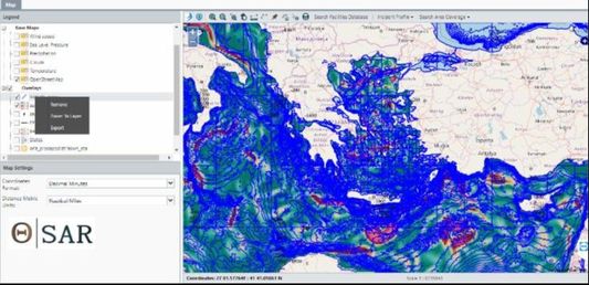
It is able to support all nautical charts such as BSB NOAA Charts, MapTech Charts, NDI Charts, NOS Charts, British Admiralty Charts (ARCS), C-MAP Charts Integration as well as open data and satellite images.
Different layers are loaded with all the necessary information a search coordinator needs, from the terra, sea and air for a complicated analysis of an incident and its search and rescue plan. Also, the search facilities are enlisted with details of their dock location, their availability and their stats. (e.g. the closest vessel to the incident’s optimal search plan area may perform a reconnaissance routing) |
|
Features
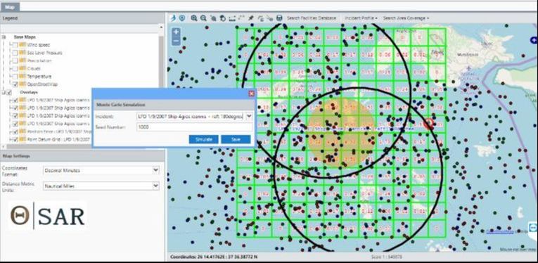
- IAMSAR and MONTE CARLO methods for computing drift
- Datum Point, Datum Line and back track search methods
- Web based tool
- Use of weather data that can accurately forecast and are meant to be integrated as automatic input for the software’s algorithms.
- Through the Automatic Identification System (AIS), which is also automatically reprocessed, the exact location and details of vessels are known to the search coordinator.
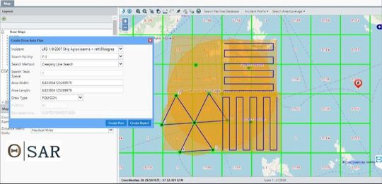
- Engage the closest vessels to an incident’s optimal search plan area allowing to perform a reconnaissance routing.
Next step
The platform aims to incorporate Unmanned Aerial Vehicles during the monitoring operations, in order to further complement the platform’s capabilities and features. With the addition of the UAV we strive to complete the solution of finding missing vessels, by taking a futuristic approach to the rescue mission, with the minimal human effort and cost combination.
