|
Products/Airbus Defence & Space/Products & Services/Software/Pixel Factory
Pixel Factory
|
The power of an industrial solution in your hands
With almost 200 remote-sensing spacecrafts already in orbit or planned, more than 200 digital cameras in use, and the huge increase of UAV solutions, several thousand terabytes of data need to be processed every year. This exploding demand for earth observation data is forcing industrial production methods.
With almost 200 remote-sensing spacecrafts already in orbit or planned, more than 200 digital cameras in use, and the huge increase of UAV solutions, several thousand terabytes of data need to be processed every year. This exploding demand for earth observation data is forcing industrial production methods.
|
Industrial geo-production system
Airbus Defence & Space has developed its own industrial geo-production system containing a revolutionary digital processing chain to produce advanced 3D mapping products of unparalleled quality. Thanks to its high capacity and native open architecture it is capable of automatically process vast volumes of raw earth observation data from multiple sensors and producing a wide range of cartographic end products:
|

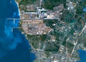
Aerial Imagery - Arcachon, France
|
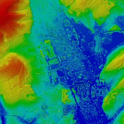
Aerial Imagery Processing - DSM 1m colour, Belfort, France
|
KEY BENEFITS
|
Airbus Defence & Space ' PIXEL FACTORY can serve a wide range of applications, including:
- Institutional such as Government and Cartographic Institute for country wide mosaic and production facilities embedded into NSDI
- Direct Receiving Station for automatic production (orthoimage, mosaic, …) based on data collected every day
- Mapping and photogrammetric companies for project and reference data production
|
PIXEL FACTORY™ is unique in that the processing of data both from satellite (optical and radar) and airborne digital cameras is a key feature built into its original core architecture.
|
Satellite Image Mosaic SPOTMaps - North of Hainan Island, China
|
|
TERRA SPATIUM, Geoinformation and Space Products & Services- Private Security Services Company S.A.
90 Ioannou Metaxa Str., 19441, Karellas Koropi, Greece P.O. BOX 049 | 19002 Paiania Greece HELLENIC BUSINESS REGISTRY NUMBER: 9340801000 Tel.: +30 210 67 48 540 | Fax : +30 210 67 53 780 |
